TL;DR
Friday's heat-and-medicine frame inverts on Saturday — highs in the 50s and 60s, flash-flood risk through Monday, and a cold-water hypothermia warning for boaters.
MSM Perspective
Baltimore Sun and Fox Weather covered the wet weekend; the NWS New York AFD carries the cold-water immersion warning.
X Perspective
X weather accounts cycled from the cleared heat dome straight to the cold-water hypothermia maps without pausing on the inversion.
The Mid-Atlantic Memorial Day forecast the paper carried into Friday — heat advisories with insulin and EpiPens on the household list — has inverted. The Weather Prediction Center's Saturday discussion puts highs across the Northeast and Mid-Atlantic in the 50s and 60s through Memorial Day, with severe weather and flash-flood risk daily through Monday. The paper runs the correction in the prose. [1]
The paper's Friday brief took the heat-and-medicine frame from the post-dome cooldown into the holiday weekend, with WPC HeatRisk still orange and red across the corridor. The Saturday tape is cleaner and colder: the dome cleared on May 19; the forecast underneath it is shower, thunderstorm and a Buffalo print of 56°/49° from WKBW. The insulin-storage chemistry that ran on Friday is still correct above 86°F. There is no Mid-Atlantic 86°F in the seven-day window. The medicine-storage rail does not apply. [1][2]
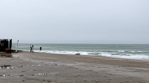
The replacement rail applies on the water. The National Weather Service's New York forecast office (OKX) is flagging cold-water hypothermia for "anyone going out on small boats, canoes or kayaks" through Memorial Day, because the air can read mild for a few hours each afternoon and the water is still in the 50s. Sudden immersion at those water temperatures causes incapacitation in minutes. NWS asks small-craft operators to wear a life vest, file a float plan, and dress for the water rather than the air. The 100th Precinct's Rockaway-beach safety meeting in early May flagged the same gap; the Coast Guard's annual reminder lands on a holiday weekend the weather has just made wetter. [3][4]
-- NORA WHITFIELD, Chicago
Sources & X Posts
News Sources