TL;DR
Tehran published a polygon of latitude-longitude lines and called it a controlled maritime zone. Abu Dhabi said its bypass pipeline is half-built.
MSM Perspective
CNBC treats ADNOC's pipeline as energy-infrastructure news; ABC's live blog lists PGSA's coordinates as a unilateral declaration without recognition.
X Perspective
X collapses the two announcements into one chokepoint-geography tape — Iran drew the line; the UAE is routing around it.
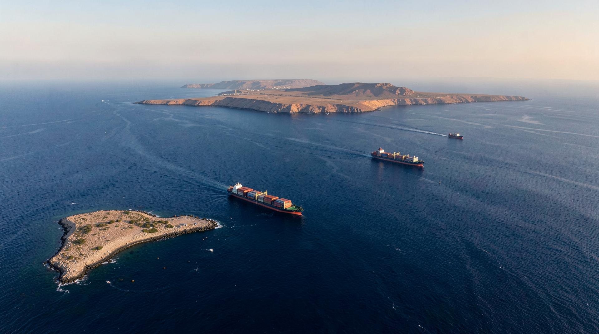
JERUSALEM — Iran's Persian Gulf Strait Authority — the agency Tehran stood up two days earlier to collect what it now calls transit fees — on Wednesday published the coordinates of a "controlled maritime zone" in the Strait of Hormuz. The polygon runs from a line connecting Kuh-e Mubarak on the Iranian coast to a point south of Fujairah on the UAE coast at the eastern entrance, to a line connecting the tip of Qeshm Island to Umm Al-Quwain at the western entrance. The authority said transit through the polygon requires its authorization. [1][2] No flag state, shipping registry, or insurer recognized the claim by close of business in either Abu Dhabi or London.
Two hours later, at the Atlantic Council in Washington, ADNOC's chief executive Sultan Ahmed al-Jaber told an audience the second Habshan-to-Fujairah pipeline was "nearly fifty percent complete" and would be operational in 2027, doubling the UAE's export capacity to the Gulf of Oman side of Fujairah port. Al-Jaber called the Hormuz blockade "the most severe energy supply disruption in history." [3] The two announcements landed on the same wires within an hour of each other.
The paper said on Wednesday that Hormuz monetization was now a three-layer regime — oil insurance (Hormuz Safe), transit certificate (the new authority's paperwork), and digital toll on subsea cables — and that the cable layer needed an "operating-side document on the second layer" before the geometry could be read as one regime. The coordinate map is that document. The Habshan-Fujairah pipeline is the counterparty answer.
Latitude and longitude
Persian Gulf Strait Authority documents seen by Iranian state media on Wednesday afternoon list the polygon's vertices in degrees and minutes of latitude and longitude. The eastern boundary connects roughly 25°30'N 56°50'E (Kuh-e Mubarak) to a point off Fujairah at 25°08'N 56°25'E; the western boundary runs from the western tip of Qeshm Island near 26°32'N 55°15'E to a point off Umm Al-Quwain near 25°34'N 55°33'E. The polygon, in other words, includes most of what international shipping law and the IMO call the traffic separation scheme — the two-mile-wide inbound lane and the two-mile-wide outbound lane that have governed Hormuz transit since 1979. [2][4]
Iran has long claimed contested authority over the western half of the Strait under the bilateral Oman-Iran median agreement, with Oman controlling the eastern half. The new map ignores the median. Muscat, on Wednesday, did not respond. Oman's silence has been the boundary on Iranian Strait authority for the last three editions of this paper, and Wednesday did not change it.
What did change is that Tehran has now produced, for the first time since the war began, a geographic-information document — vertices, edges, and a claimed jurisdiction — that an insurer or a flag state can read into a contract. Hormuz Safe, the insurance product the IRGC-aligned Tasnim agency announced two weeks ago, priced the Strait in dollars per barrel. The Persian Gulf Strait Authority's certificate priced it in paperwork. The polygon prices it in coordinates. Each layer makes the next layer's question — whose authority does a transiting vessel acknowledge by paying — sharper.
CNBC reported Wednesday evening that none of the major P&I clubs had issued a circular on the polygon by close of trading. [3] One London broker, quoted on background by Reuters last week and re-quoted Wednesday by Trade The News, said the working assumption was that any underwriter accepting PGSA paperwork on a transiting vessel was now also accepting the polygon as the jurisdictional fact of the voyage. That is the OFAC counterparty-due-diligence problem the paper named on Tuesday. The map makes the problem geographic.
Habshan to Fujairah
Al-Jaber's announcement at the Atlantic Council was, in its content, not new. The second Habshan-Fujairah pipeline has been on ADNOC's books since 2024, and Jamie Ingram of MEES has been writing about its 1.5-million-barrel-per-day Jebel Dhanna leg since March. What was new was the timing — within an hour of the polygon — and the framing. "The most severe energy supply disruption in history" is not the language an oil major's CEO uses for a market story. It is the language of a counterparty who has decided to physically route around the chokepoint and wants the routing to be public.
The first Habshan-Fujairah pipeline carries roughly 1.5 million barrels a day from the inland Habshan complex to the Fujairah terminal on the Gulf of Oman, bypassing the Strait. Adding the second pipeline doubles that capacity to roughly three million barrels a day by 2027 — enough, on the UAE's pre-war numbers, to lift nearly all of Abu Dhabi's medium and heavy crude exports out of Hormuz-dependent shipping. Saudi Arabia's East-West pipeline, which carries roughly five million barrels a day from the Eastern Province to Yanbu on the Red Sea, has been quietly running at near capacity since April. Iraq's northern export route through Turkey remains closed for unrelated reasons. The Gulf's physical bypass capacity, in other words, is being engineered upward at exactly the moment Tehran is engineering its jurisdictional capture downward.
What the coordinates mean for the cable layer
The paper has been tracking, since Sunday, the IRGC-aligned demand for a "protection fee" on subsea cables crossing the Persian Gulf — the third layer of the Hormuz monetization regime. Alcatel Submarine Networks, the world's largest cable-laying company, filed regulatory acknowledgment of a six-week force-majeure pause on Gulf repair work. No hyperscaler — Google, Microsoft, Amazon, Meta — has publicly replied to the cable-toll demand. [5]
The polygon answers a question that the cable layer left ambiguous. The IRGC-aligned demand was geographic-but-unbounded: a "protection fee" on cables in the Gulf, with no map. The Persian Gulf Strait Authority's polygon is geographic-and-bounded: a defined jurisdiction with vertices the cable consortia can plot. The eight major cables that transit the Strait of Hormuz between the Asian and European internets — including SeaMeWe-5, IMEWE, and AAE-1 — all run through the polygon. A consortium that paid PGSA for a transit certificate would, by the same coordinates, be paying for cable transit. The two layers may turn out to be the same layer.
What still has not happened
No flag state has accepted the polygon. No insurer has written PGSA paperwork into a marine policy. No port — Fujairah, Khor Fakkan, Jebel Ali, Dammam, Ras Tanura, Mina Al Ahmadi — has refused or accepted a vessel on the basis of its PGSA certificate. The CENTCOM count remains ten confirmed mines and 88 redirected vessels. Brent crude closed Wednesday at the IEA-stock-draw-bounded waiver-rumor band the paper described on Tuesday, inside which the operating record has held for a week. The fourteen-point Pakistani channel produced no text Wednesday.
What the polygon did produce was a coordinate-level argument that has now to be answered, or refused, or ignored, by every counterparty whose vessels, cables, oil, insurance, and lending touch the Strait. The UAE answered with a pipeline. Saudi Arabia is answering with East-West throughput. China — whose three tankers left the Strait this week without incident, on routes the Hormuz Safe regime is built to absorb — has not yet answered in language. Oman has not answered at all.
Iran drew the line. The map is on the wires. The question now is how many flag states will sail through the polygon without paying, and how long the polygon survives the first refusal.
-- YOSEF STERN, Jerusalem
Sources & X Posts
News Sources
X Posts