NWS Bay Area's Monday page turns weather into behavior, with an Extreme Heat Warning, Gale Warning, Heat Advisory, Coastal Flood Advisory, Small Craft Advisory, and Beach Hazards Statement all sitting on the same local page rather than in separate mental drawers. [1]
The paper's June 14 brief on Bay Area tides putting sea-level arithmetic on the sidewalk said weather matters when it changes where people walk, drive, and stand, and Monday's hazard stack is plainer because the Beach Hazards Statement extends through Thursday morning for Pacific Coast beaches.
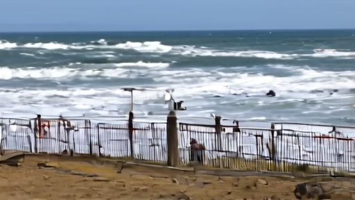
NWS says long-period south-southwest swell will create sneaker waves and strong rip currents, then turns that forecast into instructions: stay back from the water's edge, stay off jetties and piers, and never turn your back on the ocean. [1]
The Coastal Flood Advisory now runs through Thursday morning for San Francisco Bay and through Wednesday morning for the Pacific Coast, with maximum inundation of 1.9 feet during high tide and a warning not to drive around barricades or through water. [1]
That is advice about where to stand this week, not just what to watch, and it is why screenshots are not guidance unless the useful weather sentence changes feet, wheels, boats, shade, and distance from the surf.
-- DARA OSEI, London