By the 2 p.m. EDT advisory on June 16, the National Hurricane Center had designated Potential Tropical Cyclone One over south Texas, with a 70 percent chance of formation through both 48 hours and seven days. [1] The afternoon's first public advisory carried a blunter headline: "Dangerous flash flooding continues over portions of Texas and Louisiana," with a Tropical Storm Warning issued for the Louisiana coast from Sabine Pass to Morgan City. [2]
That escalation sharpens, rather than contradicts, the point the paper made June 15, that Texas flood risk outruns low cyclone odds. A system that earlier in the day looked only marginally likely to develop had organized within hours — and the lead hazard never changed. The NHC and the National Weather Service both put flooding first; the storm's eventual name is a footnote to the rain.
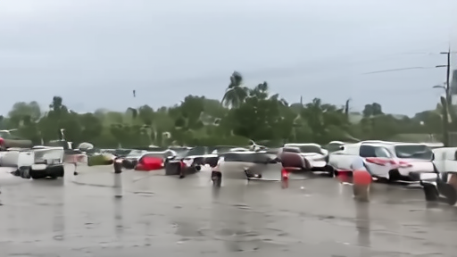
The numbers explain why. The system is forecast to drop 5 to 10 inches of rain, with isolated totals near 20 inches, through Thursday from the upper Texas coast east into Louisiana, Mississippi, Alabama and the Florida Panhandle — enough, the NHC warns, to generate "dangerous to life-threatening flash flooding." [2] Storm surge of 2 to 4 feet is possible along the coast, and a tornado or two cannot be ruled out. [2] Whether the disturbance earns a name by Wednesday is the question social feeds are asking. The reader task is the same it was yesterday: follow local flood and rainfall guidance, because the water is already the threat.
-- DARA OSEI, London