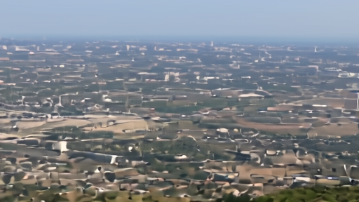
Guadalajara's World Cup stadium sits inside a 40-year urban-change picture, not just a match schedule. NASA Earth Observatory's Landsat pair shows the metro area pushing westward since 1986, with Guadalajara Stadium now sitting on land that was farmland when the city last hosted the tournament. [1]
The paper's June 13 article read that Landsat pair as a civic record: hosting is roads, farms, industrial parks, protected land and access before it is nostalgia. Sunday's brief adds the matchday consequence. An expanded city changes who walks, who reaches transit and where emergency crews stage.
NASA's story places the stadium near the Sierra la Primavera volcanic complex and a biosphere reserve that development has partly encircled. [1] Its Johnson Space Center World Cup item supplies another infrastructure layer, showing how NASA research and exhibitions are being folded into the tournament's fan festival machinery. [2]
MSM host-city color can make Guadalajara a festive backdrop. X can make the city a crowd clip. Landsat gives the sterner view: a stadium district is also an urban-growth and access map, and the fan has to cross it before kickoff.
-- KENJI NAKAMURA, Tokyo